FROM THE MAIN BLOG:
Originally posted on 10 July 2012
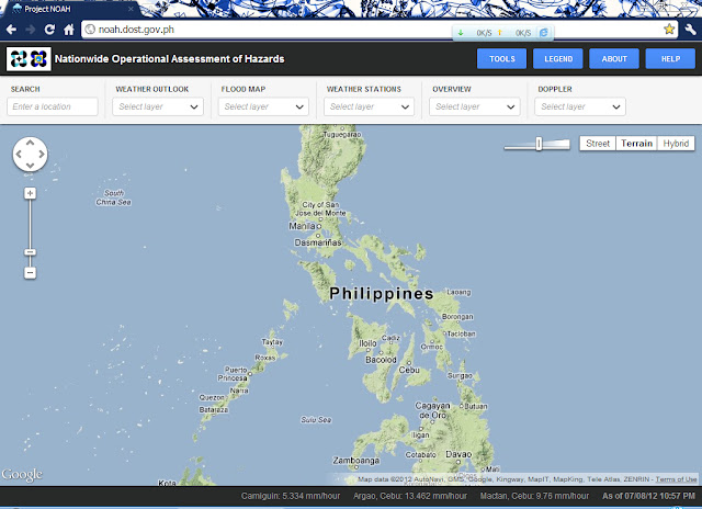
Have you ever heard of Project NOAH? It's in the news these past few days upon its formal launch last Friday (July 6).
How about ClimateX? Dito medyo magtataka na kayo ano 'tong bagay na 'to.
Project NOAH stands for "Nationwide Operational Assessment of Hazards". Sa naturang proyekto, one can see weather conditions in a locality in the Philippines in "near real time".
By the way, the URL of Project NOAH is http://noah.dost.gov.ph
 |
| (Above) Project NOAH screenshot. Click on the image for larger view. |
The Project NOAH
uses Google Map, so I think everyone's very familiar of its use, from
zooming to changing terrain to hybrid interface.
To start with, nakikita naman po ninyo sa itaas ng webpage na iyan ang "Tools Menu" kung tawagin.
Mayroon
pong "Search", "Weather Outlook", "Flood Map", "Weather Stations",
"Overview" at "Doppler". I'm not focusing on the first five tools
mentioned. As this post's title dictates, I will talk about Doppler
radars here.
Pero bago po muna 'yan, una
ko pong narinig o nabalitaan itong Project NOAH sa isang YouTube video
(you can watch that below) almost a month before pa nung formal
launching. That was last June 13, 2012.
Tulad
ng banyagang nakita ninyo doon, I'm also one of those who were waiting
for the Philippine Doppler radars to be publicized, I mean, for the
public to see. Limitado lamang po ang ipinapakita ng PAGASA sa publiko
nitong mga nakaraang mga taon. Last May 2011 nang ilabas ng PAGASA ang
isang Doppler radar animation mula sa Baler station na ipinapakita ang
kilos ng noo'y bagyong Chedeng sa kanilang Twitter; inakala ko pong
tuloy-tuloy na ang paglalabas nito ngunit hindi po nagtagal ay still
images na lang ang kanilang inilalabas, and there was a time that only
MTSAT-EIR satellite images were uploaded.
 |
Typhoon Chedeng as seen on this radar animation
from PAGASA's Baler radar station. |
Nawala
po ulit ang pag-asa kong makita muli ang Doppler radar images. Sayang
lang kung sosolohin lang nila ito. Sa aking pananaw po kasi, if Doppler
radar images are publicly released and are updated from time to time,
ordinary people like me can now rely not only to their (PAGASA's)
six-hourly weather advisories and forecasts (remember, many things can
happen within six hours), but also to this frequently-updated weather
tool for our safety, without waiting for six hours for another advisory.
Kaya
naman nung nabalitaan ko ang Project NOAH na ito, hindi na po ako
nag-atubili. I visited the site and poof! Four Doppler radar animations
flickered my meteorological interest anew.
 |
PAGASA radar network featured in Project NOAH, four radar stations are shown:
Subic, Zambales (uppermost circle); Tagaytay City, Cavite (mostly overlapping Subic radar image's circle);
Mactan [Cebu] (circle over Central Philippines); and Hinatuan, Surigao del Sur (rightmost circle). |
Well,
this screenshot is not how Project NOAH's Doppler section looked like
at first. Sa pagkakatanda ko, hindi rainbow color scale ang gamit noong
una, "bluescale" 'ata tawag dun (kung may ganun man), which is, the
darker the blue color over an area, the heavier the rain is expected
there. Ngayon, as you can see at the right part of the image above,
makulay na color scale is now used; 'pag pink to white ang color na
nakikita on screen, ibig sabihin ay madami ang ulang dala ng kaulapan
over the locality covered by the colors. In that picture, cyan-to-blue
yung nakikita natin over Central Visayas, which means 0.1 up to 0.6
millimeters per hour (mm/hr) ang dalang ulan ng mga kaulapan doon, to
make things simple, light rains are expected to pour over there.
Nakakuha
din po ako ng still images ng mga Doppler radar stations ng PAGASA na
nakalabas sa Project NOAH, pero ito po'y galing sa isa pang
weather-oriented site na ClimateX (http://climatex.ph).
Hindi
ko alam kung maaari bang tawaging "sister site" ng Project NOAH ang
ClimateX dahil karamihan sa data ng huli ay inilalabas din ng una.
Pakitignan po ninyo ang screenshot sa ibaba.
Meron
itong "Rain Forecast" na meron din sa Project NOAH ("Weather Outlook"
>> "Probability of Rain"); meron siyang MTSAT images na nakalabas
din sa NOAH ("Overview" >> "MTSAT"). It also releases current
rainfall data in several parts of the Philippines, but again, NOAH has
it also ("Weather Stations" >> "Weather Stations")! Yet, above
all, they both give us the latest Doppler radar images.
Just
what I've stated earlier, I got Doppler radar images from ClimateX. I
decided to post them here to give you a view of the coverage of each
radar station shown in NOAH.
 |
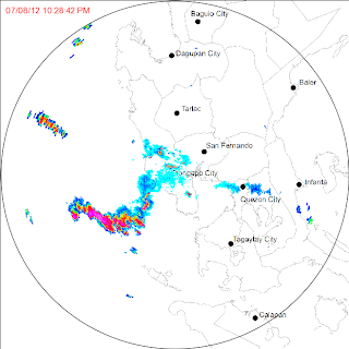
PAGASA Subic Radar image
as of July 8 at 10:28PM (From: ClimateX) |
First we have this image from Subic radar station. It almost covers
the entire Region III and Region IV-A, and it is a vital source for
accurate rainfall forecast for the said regions as well as for the
National Capital Region or Metro Manila.
If I have to name its coverage by provinces, it goes this way:
Region I: Pangasinan, and southern part of La Union;
Cordillera Region: southern part of Benguet including Baguio City;
Region II: All except the northern part of Nueva Vizcaya, and southern part of Quirino Province;
Region III: Zambales, Tarlac, Bataan, Pampanga, Nueva Ecija, Bulacan, and western section of Aurora including its capital Baler;
Region IV-A: Rizal, Laguna, Cavite, Batangas, and most parts of Quezon Province including Lucena City and the Polillo Islands;
Region IV-B: northern part of Occidental Mindoro including Lubang Islands, and northern part of Oriental Mindoro including Calapan City;
and Metro Manila.
 |
PAGASA Tagaytay Radar image
as of July 8 at 10:16PM (From: ClimateX)
|
Ang
nasa kanan naman po ang Tagaytay radar. It also covers almost the
entire Regions III and IV-A, including Metro Manila, and some parts of
Region IV-B. The provinces covered are:
Region I: southernmost sections of Pangasinan;
Region II: southernmost part of Quirino;
Region III: Tarlac, Pampanga, Bataan, Bulacan, most parts of Zambales and Nueva Ecija, and southern section of Aurora including Baler;
Region IV-A: Rizal, Cavite, Laguna, Batangas, and almost the entire Quezon province including Polillo Islands;
Region IV-B: Marinduque, Occidental Mindoro including Lubang Islands, and Oriental Mindoro;
Region V: western section of Camarines Norte, and some parts of Camarines Sur;
and Metro Manila.
Why
there are two Doppler radar stations covering Metro Manila? I think its
because if one of them shuts down for any technical reason, there is at
least another station that can monitor the amount of rain in the clouds
over the metropolis.
Kung
hindi ako nagkakamali, pansamantalang ipinatay ang Subic radar station
last 2011 sa kasagsagan ng Bagyong Juaning dahil sa napakasamang panahon
doon. So at least Tagaytay station can give radar images to PAGASA
Central Station sa Quezon City.
 |
PAGASA Cebu Radar image
as of July 8 at 10:14PM (From: ClimateX)
|
Next, we have the Cebu radar station which covers 70-80% of the entire Visayan region.
Makikita naman natin sa kanan na umulan sa malaking bahagi ng Kabisayaan partikular sa Dumaguete City, Cebu at Bohol.
Ang nasasakupan ng Cebu radar ay ang mga sumusunod na mga lalawigan:
Region V: southern part of Masbate;
Region VI: Negros Occidental including Metro Bacolod, Guimaras, majority of Iloilo province including Metro Iloilo, central and eastern parts of Capiz including Roxas City;
Region VII: Negros Oriental, Cebu province including Metro Cebu, Siquijor, and Bohol;
Region VIII: Biliran, Leyte, Southern Leyte, southern part of (Western) Samar including Catbalogan City, and southernmost part of Eastern Samar;
Region X: Camiguin, northernmost tip of Misamis Occidental, and little portions of northern Misamis Oriental;
Region XIII: Dinagat Island, and western part of Surigao del Norte including Surigao City.
 |
PAGASA Hinatuan Radar image
as of July 8 at 10:13PM (From: ClimateX)
|
And
lastly, the PAGASA radar station in Hinatuan, Surigao del Sur. Its
covers the eastern section of Mindanao. It covers the following
provinces:
Region X: Bukidnon, central and eastern portions of Misamis Oriental including Metro Cagayan de Oro, and eastern portion of Camiguin;
Region XI: Davao del Norte, Compostela Valley, majority of Davao Oriental including Mati City, and northern part of Davao del Sur including Metro Davao and Island City of Samal;
Region XII: northwest section of North Cotabato;
Region XIII: Surigao del Norte, Surigao del Sur, Agusan del Norte, Agusan del Sur, and southernmost tip of Dinagat Island.
Cagayan
de Oro City is not seen for it is overlaid by red-to-pink colors of the
radar imagery. Therefore, moderate to heavy rains were pouring down in
their area at that time.
Last
July 3 or 4, Project NOAH also included radar animations from the
PAGASA Baguio radar station. However, it was not updating and it was
removed from the site two days before the formal launching.
Sa
nakikita ninyong screenshot sa itaas, nagpapatunay lang na minsang
isinama sa Project NOAH ang Baguio radar. Unfortunately, I wasn't able
to grab an actual screenshot of radar images of the said station.
Tuwang-tuwa
ako sa Project NOAH at sa ClimateX, dahil sa pagsasapubliko ng Doppler
radar data nito. Gayunpaman, alam ko pong sinisikap pa rin ng PAGASA at
ng DOST na mapabuti ang pagtataya ng panahon dito sa bagyuhing bansa ng
Pilipinas sa tulong na rin ng mga naitayo nang radar stations.
May
iba pa pong Doppler radars ang hindi pa nakapaloob sa Project NOAH.
'Yun nga, ang sa Baguio na saglit lang nagpakita, at ang sa Baler,
Aurora na may "blind spot" sa bandang kanluran ng istasyon dahil sa
nagtataasang Bulubunduking Sierra Madre. Operational na rin ang sa
Virac, Catanduanes na siyang pinaka-advanced Doppler radar facility sa buong mundo sa ngayon. Two more Doppler radars are operational, namely, in Guiuan, Eastern Samar and in Tampakan, South Cotabato.
Kasalukuyang
itinatayo ang radar facility sa Aparri, Cagayan which will serve
Northern and Central Luzon together with the Baguio radar. While radar
stations in Busuanga (in Palawan, to cover Mindoro, Palawan and West
Philippine Sea area), in Iloilo City (mainly for Western Visayas), and
in Zamboanga City (for the Zamboanga Peninsula and the Sulu
Archipelago).
Binabalak
din 'atang magtayo ng iba pang radar stations sa Pangasinan at
Camarines Norte. Pero 'di ko alam kung matutuloy pa ba ang mga 'yun.
Sighs
or relief were now heard from weather enthusiasts like me for having
these Doppler radar images accessible anytime through Project NOAH and
ClimateX.
I congratulate PAGASA, DOST and also the Philippine Government for these efforts! Mabuhay po kayo! God bless your work!
>> rrj@chn_2012-07-10


